India celebrates its 75th independence day on this 15th of August 2021. As innocent children long ago, the concept of nation, national boundaries and India as a geopolitical entity; all were limited to Geography, History and Civics text books. An inch of distortion in drawing it to scale would invite a reduced score in the tests and a loud dig at the student by the teacher for giving away territory or snatching territory without war!! In fact, free hand drawing of the map of India would always end up giving territory or destroying her beautiful arches and claiming some of China, Nepal, Myanmar and Pakistan! Child’s play, you see!😀
But on the eve of our Independence day, some disturbing recent events have made me look at the changing territorial boundaries of my nation as it has evolved from the Bharatvarsh it was thousands of years ago, to the incredible India it is today! According to the Vishnu Purana written around 600 BC :
उत्तरं यत्समुद्रस्य हिमाद्रेश्चैव दक्षिणम् ।
वर्षं तद् भारतं नाम भारती यत्र संततिः।।
Uttaraṃ yatsamudrasya himādreścaiva dakṣiṇam
Vishnu Purana(Verse 2,1,31)
varṣaṃ tadbhārataṃ nāma bhāratī yatra santatiḥ.
This shloka means: “The country/ landmass (Varsam) that lies north of the ocean and south of the snowy mountains is called Bharatam; there dwell the descendants of Bharat. Bharat was a king and this land getting his name is a story in itself. They used this term to distinguish it from other varsas or continents.
Amazing fact is that this Bharat Empire i.e. Bharatvarsha, Hindustan or India included the present Pakistan, Afghanistan, parts of China, Iran, Tajikistan, Uzbekistan, Kyrgyzstan, Russia, Turkmenistan, North-West Tibet, Nepal and Bangladesh. Interestingly, same Bharatvarsh was referred to as Jambudwipa in some ancient texts.
Here I present the changing shape of my beloved country India a name it was given by Western invaders in the 16 th century . Ironically, one of the oldest countries in the world, enters it’s seventy-fifth year of free existence once again, after two hundred years of colonial domination.
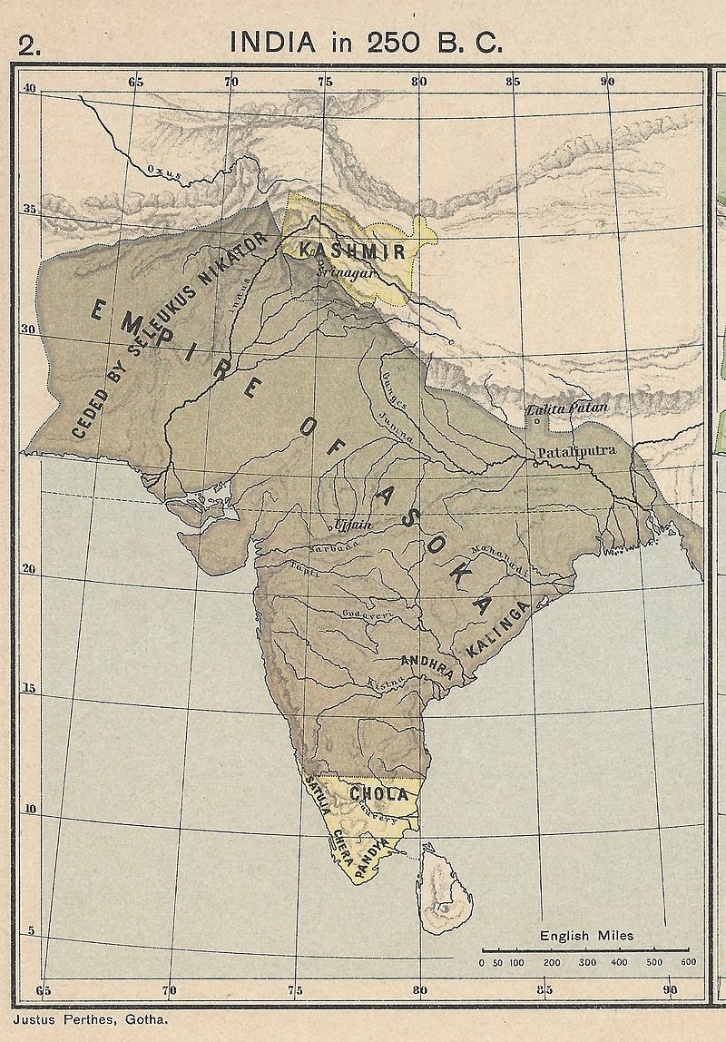
Jambudwipa 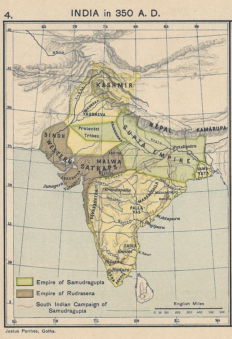
Bharatvarsh 
Hindustan 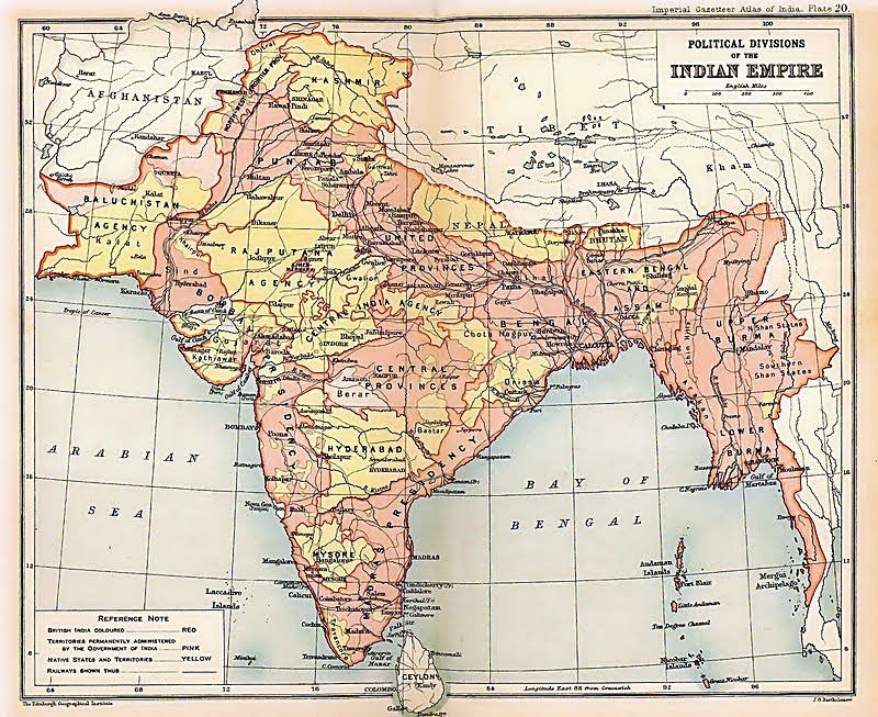
India during the British rule 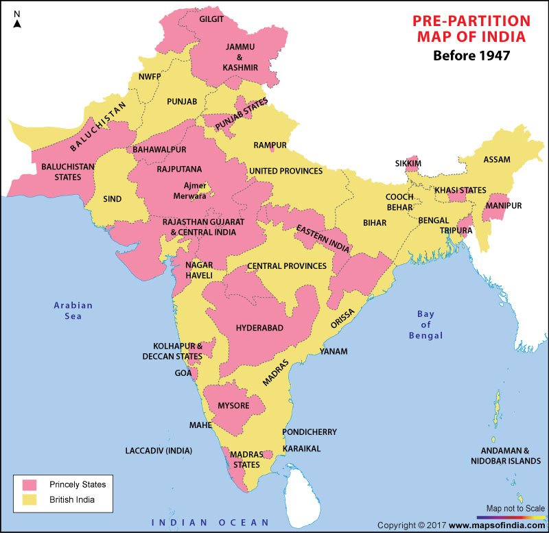
India before the partition of 1947 
India post partition 
I leave it to you my discerning reader, to see how territories were shaved off in acts of aggression and of deceit by oppressors, rulers and neighbours. To top it all, still wet behind the ears map makers of some social media platforms with autoCAD as their only tool of knowledge have also taken it upon themselves to give a definitive territory to India.
P.S : The story of India is quite long and cannot be contained in this microblog. I invite you to do your own reading to understand the sentiment.Long Live my Country! Jai Hind!🇮🇳

Thank you dear for bringing this up. My kids found this so interesting.
Yes the story of India is unique and incredible. The more you learn the more you get into it.
God bless my India and may we be able to love and protect it .
LikeLiked by 2 people
I am so glad you liked the post and it managed to interest your children. Thank you so much Arpita 💟
LikeLike
Congrats to you – even through your challenges, still standing
LikeLiked by 2 people
Thank you dear Beth for your good wishes. Yes, the challenge continues but no problem comes without a solution, so…
LikeLiked by 1 person
Name of our beloved country should b changed to “Bharatvarsha” . Both, Hindoostan and India, are names given by aggressors.
We should hv followed the path of Sri Lanka, Myanmaar, etc.
LikeLiked by 2 people
Why not! Your wish may appear in the General elections manifesto 😊 Thank you for dropping by and adding your thoughts here
LikeLike
We in Bengal still call India as Bharatvarsha.
As a child I had asked this to my maternal grandfather. Why do Bengalis call India as Bharatvarsha? And he had patiently answered .
Fond memories.💖
LikeLiked by 2 people
Bengal has always been one of the custodians of all things Indian. That is the beauty of this province, hosted the East India company for the longest time and still retains its identity. Thank you dear Arpita for sharing your thoughts here… ❤️😊
LikeLiked by 1 person
Partition was one thing in the process of independence which we can’t truly accept yet we should. Independence came with a cost. and now Jai Hind!
LikeLiked by 2 people
Thank you team DD for reading and sharing your thoughts here.
LikeLiked by 1 person
Your blogsite started showing up on your name link now. Thank God. I was unable to read your posts earlier as everytime it said ” the site is empty”.
LikeLiked by 1 person
yeah it was a problem for sometime. Now it has resolved!!
LikeLiked by 1 person
One of your best Artcles I have ever read. You have Described Bharat so well from Ancient time till today. Loved it ❤❤Jai Hind Jai Bharat. 🙏😊
LikeLiked by 2 people
Thank you so much for liking the post Pratibha. Your kind words of appreciation have certainly made this day very special! Happy Independence Day!🇮🇳 Jai Hind
LikeLike
Happy Independence to you too. Jai Hind🙏
LikeLiked by 1 person
I really loved the content especially thepictures of India .All the best sushmita
LikeLiked by 1 person
Thank you so much for liking this post Rose. Keep dropping in to read my posts 🌹❤️
LikeLike
Nice information..
LikeLiked by 1 person
Thank you for dropping by and liking this post sir
LikeLiked by 1 person
Nice post
LikeLiked by 1 person
Thank you
LikeLike
Jai hind🇮🇳
LikeLiked by 2 people
thank you for dropping in to read this post
LikeLike
How interesting, thankyou dear
LikeLiked by 2 people
Thank you so much for liking the post David
LikeLike
Please check your link, the site is showing empty on first click
LikeLike
Thankyou dear, which link shows the empty lah
LikeLike
Die Gum Sarn …takes you to a page which says goldfields to gold dust … this site is empty
LikeLike
Ah I see mmhh needs work, I will attempt to correct presently
LikeLike